Landforms & Water Features
updated October 1, 2025
Recorded here is my own personal collection of articles, resources, favorite links, teaching ideas, and lesson plans. It encompasses many years, from the very beginning of my experience studying and learning about Waldorf to the present time. People from all around the world visit my site and recommend it to others. Welcome!
This site records my journey. I hope my honesty is encouraging and helps break down some barriers that may prevent people from trying Waldorf methods. Because this is an ongoing site documenting my curriculum planning and ideas, some materials are more Waldorf-y than others. Please feel free to take what you like and leave the rest.
This page has helpful links and LOADS of free resources to help you plan your fourth grade year. Enjoy!
Mission Statement - Consulting Services - Lending Library
Forms in Water & Earth
for Class 4
5-DAY ONLINE COURSE:
Waldorf Main Lesson Block Planning: Forms in Water & Earth
Join a community of fellow homeschoolers planning this exact same main lesson block for plenty of help and support.
This course is aimed at homeschoolers who are already familiar with the Waldorf method, but
would appreciate extra feedback and encouragement in planning this block.
Make friends and ask specfic questions of
an experienced Waldorf homeschool teacher and consultant as you work through this inspiring, do-able, step by step course.
Lifetime access.
Just $30.00!
Rationale
I taught the fourth grade Local History & Geography block at our homeschool co-op in September 2018. Looking back,
I have realized that we did a LOT with local history, geography, and industry but we didn't do a lot with
landforms, water features, or map skills (like the compass rose).
In my opinion, I think this would work best as two blocks, so I am creating a separate Landforms &
Water Features block. I will post all of my notes as to what we do below and put photos on my blog.
The largest body of water west of the Mississippi disappeared 130 years ago -- now it's back
northeastern.edu
Where in the World Do We Send Our Recycling?
These six graphs show how Hawaii's trash circled the globe last year.
May 18, 2020
The Kauai Landfill 'Conundrum' Could Quickly Become A 'Public Health Hazard'
May 11, 2022
Books to Buy
Originally my notes for this topic said, "There is no main book to purchase for this topic." But now I have changed my mind!
When we did our field trip to the public library to look up books (Dewey Decimal number 551),
I found this incredible resource! It is absolutely ideal for this block.
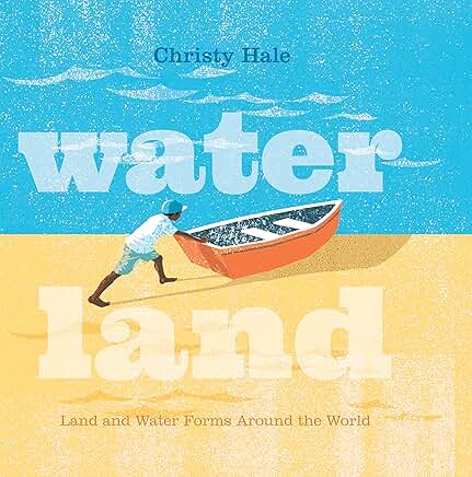 Water Land: Land and Water Forms Around the World by Christy Hale
I would use this book as my sole resource for the Basic Forms. It shows them as mirrored shapes, as in the Montessori style. It has a list of real-life examples found around the world. And it has a world map with an example of each one highlighted.
I would use this book in weeks 1 & 2, and then introduce the advanced vocabulary and the poster projects in weeks 3 & 4. We could also do the extra step of getting a world map and putting a pin in it for each of the children's real-life examples!
I love using a fabulous Montessori material from Mandala Classroom Resources: Landforms
& Water Features Set of 38 three part cards ($49.00). Three part cards are designed for the student
to work independently, matching Picture, Name, and Definition. The cards are labeled on the back for control of error. This
means that students can check their work
on their own by flipping the cards over to see if they are correct. Highly recommended!!
I am doing this block in September 2019, interweaving it with Form Drawing (the archetypal
shapes around us are found also in the land) for my first graders and using
it to transition them into Capital Letters in October (Mountain, Valley, Cave, River, etc.). For my older students
this will be a Science main lesson book.
I am beginning the school year in the last week of August with an introduction to Form Drawing. Then in September,
the first graders will continue 1st grade FD and the older children will move into 2nd and 3rd grade FD. The landforms
and water features will progress accordingly, with mirrored forms (the classic way of presenting landforms and
water features in Montessori is to see them as opposites of each other, like island/lake) and then with metamorphosis forms.
We are doing 32 of the 38 cards. We are not using the cards for continent, continental shelf, cape, pass, ria, or bight.
Our read aloud story for this block: Abel's Island by William Steig
WEEK ONE
Day One - Reef
Day Two - River
Day Three - Cave
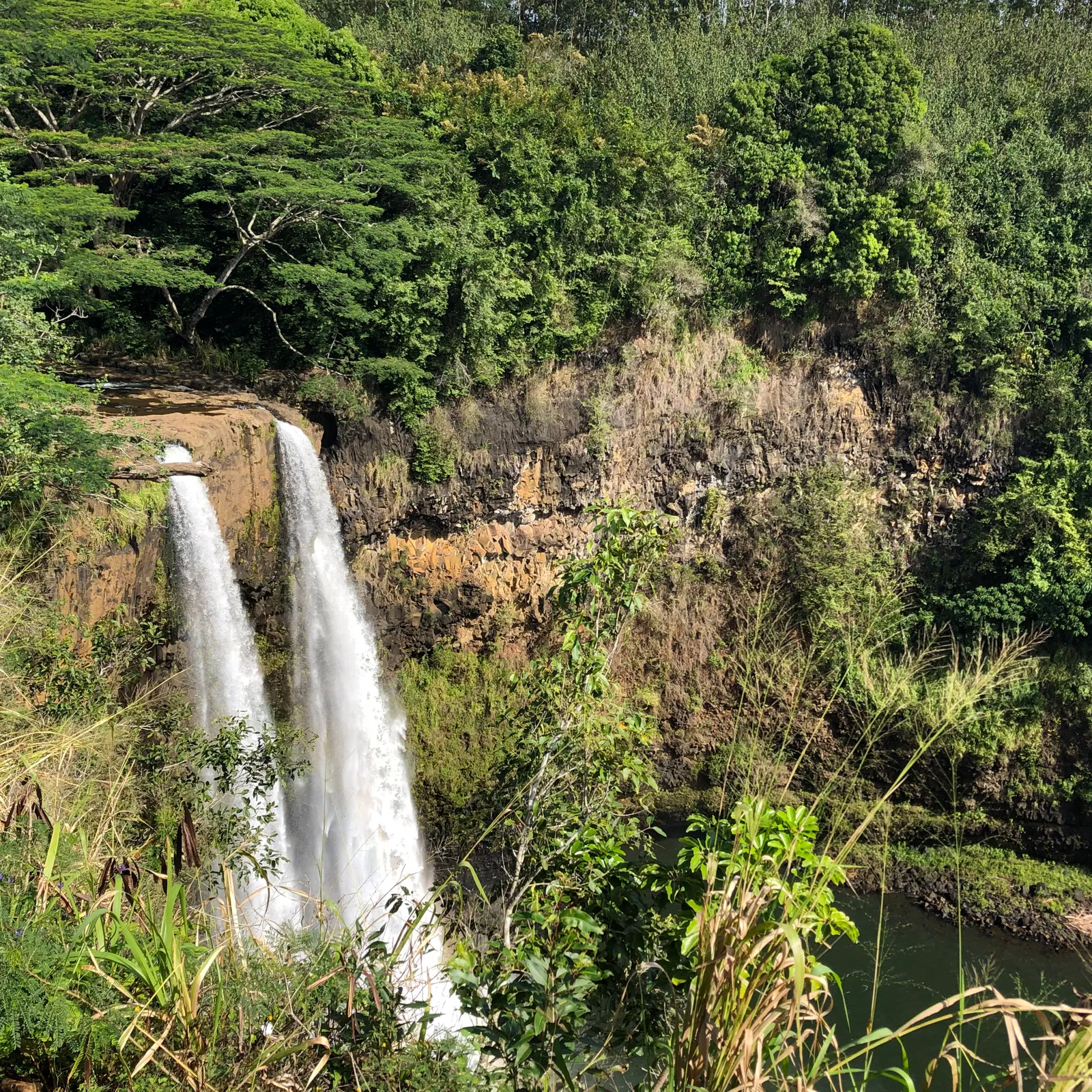
Day Four - Waterfall
WEEK TWO
Day Five - Island / Lake Mirrored
Day Six - Mountain / Valley Mirrored
dig and make in yard
National Geographic map Mount Everest
National Geographic map Alps
National Geographic map Great Rift Valley
National Geographic map Indian Ocean Floor
National Geographic map Arctic Ocean Floor
Day Seven - Isthmus / Strait Mirrored
dig and make in yard
National Geographic maps World - Panama, Strait of Magellan
Day Eight - Peninsula / Gulf Mirrored
dig and make in yard
National Geographic map Italy
National Geographic map United States - Florida, Gulf of Mexico
WEEK THREE
Day Nine - Gulf / Lagoon Metamorphosis
make metamorphosis in clay
Day Ten - Volcano / Crater Metamorphosis
vintage postcard of Mount St. Helens before eruption
Volcanoes, pp.12-13 from Earth by the Numbers by Steve Jenkins
pumice from my hike up Mount Vesuvius
Waseca Biomes Rock Cycle Mat
This Dynamic Planet Map from USGS - Ring of Fire
torn paper collage artwork with Mod Podge - volcano
crater on moon demonstration in flour

Earth by the Numbers
by Steve Jenkins
Day Eleven - Desert / Oasis Metamorphosis
watercolor paintings of desert vs oasis
Day Twelve - Glacier / Fjord / Iceberg Metamorphosis
WEEK FOUR
Day Thirteen - Archipelago / Atoll / Reef Metamorphosis
make metamorphosis in clay
National Geographic map World - Japan, Hawaii
National Geographic map Philippines
National Geographic map Indonesia
Day Fourteen - Plain / River / Canyon Metamorphosis
Day Fifteen - River / Estuary / Bay Metamorphosis
Day Sixteen - River / Tributary / River Basin / Delta Metamorphosis
Big Muddy River Tributary (page 58 of Minn of the Mississippi by Holling C. Holling)
Nile River Delta
dig and make in yard
field trip to Inspiration Point (view overlooking Mississippi River basin)

Minn of the Mississippi
by Holling Clancy Holling

Geology Underfoot in Illinois
by Raymond Wiggers
#32 - A Fault-Seeking Expedition
Fountain Bluff to the Pine Hills Escarpment, Jackson County
WEEK FIVE
Day Seventeen - Plain / Plateau / Butte / Earth Pillar Metamorphosis
My blog posts from teaching this block:
|


